


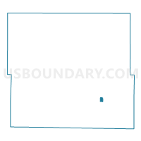
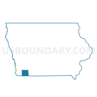
SHAMBAUGH Voting District, Page County, Iowa
About
Outline

Summary
| Unique Area Identifier | 582994 |
| Name | SHAMBAUGH Voting District |
| County | Page County |
| State | Iowa |
| Area (square miles) | 0.36 |
| Land Area (square miles) | 0.36 |
| Water Area (square miles) | 0.00 |
| % of Land Area | 100.00 |
| % of Water Area | 0.00 |
| Latitude of the Internal Point | 40.65747520 |
| Longtitude of the Internal Point | -95.03524650 |
Maps

Graphs
Select a template below for downloading or customizing gragh for SHAMBAUGH Voting District, Page County, Iowa


Neighbors
Neighoring Voting District (by Name) Neighboring Voting District on the Map
- AMITY TWP W/O BRADDYVILLE Voting District, Page County, IA
- BUCHANAN TWP W/O BRADDYVILLE Voting District, Page County, IA
- EAST RIVER TWP W/O CLARINDA Voting District, Page County, IA
- HARLAN TWP W/O CLARINDA & SHAMBAUGH Voting District, Page County, IA
Top 10 Neighboring County Subdivision (by Population) Neighboring County Subdivision on the Map
- Amity township, Page County, IA (430)
- Harlan township, Page County, IA (391)
- Buchanan township, Page County, IA (269)
- East River township, Page County, IA (254)